| Drought in the West tinyurl.com/diresituationphotos | A Photographic Essay |
Reno/Truckee Meadows
|
Next → |
Interactive Cartograph: Clickable place names, horizontally scrollable.

Where does Reno's drinking water come from?
Using this siteYears of research and observations have resulted in this diagram/photo essay of Northern Nevada's Northern Lahontan watershed and conditions during drought.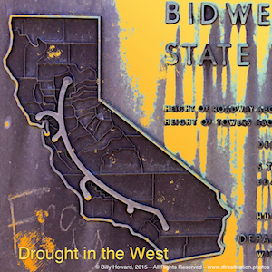
Plaque on Bidwell Bar Bridge depicting California State Water Project including the California Aqueduct from Lake Oroville to San Diego.
Connecting the dots of the Truckee Meadows and Northeastern California fresh water sources, each page bears photos of the location, videos, critical data including historic and often an important news piece about the drought situation such as Why fresh water shortages will cause the next great global crisis, The Guardian, UK.
The fresh water source diagram at the top of all pages is scrollable. Move to the left to see the full diagram. Click on a location or use the navigation in the upper right of every page to go through the system sequentially. Not all pages are completed, but will be soon.
You may also choose a site from the selected images below.
Hope this labor of love proves helpful and informative.
Best Regards,
Billy Howard, 5.10.15 (with continual updates).INSTRUMENTS:Canon EOS 7D:
Canon EF 50mm f/1.8 II
Hero3-Black Edition
Canon EF-S 17-85mm f4-5.6 IS USM
Canon EF 28-300mm f/3.5-5.6L IS USM
Parrot AR Drone 2.0 720p - 30FPS - H264 encoding base profile, Wide angle lens : 92∞ diagonal
iPhone 5s back camera 4.15mm f/2.2
iPad Air 2 back camera 3.3mm f/2.4
|
|

|
|
|
|
|
||||
|
|
|
|
|
|
|
||||
|
|
||||
|
|
|
||
|
|
||||

|
|
|
||
|
|
||||